Project 1: On the role of aerosol atmospheric rivers on Greenland ice sheet darkening
|
Disciplines: |
Atmospheric Science, Climate Science |
|
Mentor (JPL): |
Duane Waliser Email: duane.e.waliser@jpl.nasa.gov Phone: 818.393.4094 |
|
Mentor (UCLA): |
Gang Chen Email: gchenpu@ucla.edu Phone: (310)206-9956
Bin Guan Phone: 310.794.9832 Email: bguan@ucla.edu |
|
Background: |
Increasing temperature due to global warming and associated climate change impacts are melting the ice sheets in Greenland at an unprecedented rate. Snow darkening by black carbon (BC) aerosols significantly amplify the greenhouse effect by two times (Hansen & Nazarenko, 2004) and accelerate ice sheet melting (Strong et al., 2009) because they absorb sunlight, warm the surface where they deposit, and darken the snow and ice surface. Darker snow absorbs more incoming sunlight that can lead to accelerated melting and lower reflectivity of the incoming solar energy– leading to a positive feedback loop and resulting in a higher rate of melting (Flanner et al., 2007; Tedesco et al., 2016). In addition, BC aerosols directly absorb incoming solar energy and increase the temperature of the snow surface, thus can amplify the melting due to greenhouse effect. Aerosol atmospheric rivers (AAR), long and elongated channels of strong wind and extreme mass transport, can transport these aerosols to long distances - often intercontinental. Studies show that BC particles generated over the US and east Asia can often reach Greenland due to AAR activities (Chakraborty et al., 2022; Chakraborty et al., 2021). Only 20-30 of such activities in a year can transport 40-80% of total annual transport of BC particles in Greenland. The snow darkening phenomena is very complex and how BC aerosols affect the snow albedo, modulate the radiative properties like surface temperature and radiation, and accelerate the melting process is still unknown. |
|
Description: |
The student will analyze satellite data to detect the causality among various features that can darken the snow and accelerate melting. Such analyses would be carried upon the southern Greenland region where the melting is the strongest. Satellite data sets to be analyzed include AIRs, CERES, ICESat 1 and 2, and MODIS. The AAR database has already been created and will be provided to the student. This study will improve our understanding of the impacts of global warming and the snow darkening effect of aerosols on ice sheet melting in general. The investigation of how black carbon aerosols accelerate the current melting rate of Greenland ice sheet due to global warming is expected to significantly advance the current state of knowledge and will help scientists to estimate future rates of melting and inform decision makers about the sea level rise in the future. |
|
References: |
Chakraborty, S., Guan, B., Waliser, D. E., & da Silva, A. M. (2022). Aerosol atmospheric rivers: climatology, event characteristics, and detection algorithm sensitivities. Atmospheric Chemistry and Physics, 22(12), 8175-8195. https://doi.org/10.5194/acp-22-8175-2022 Chakraborty, S., Guan, B., Waliser, D. E., da Silva, A. M., Uluatam, S., & Hess, P. (2021). Extending the Atmospheric River Concept to Aerosols: Climate and Air Quality Impacts. Geophysical Research Letters, 48(9). https://doi.org/ARTN e2020GL091827 Yasunari, T. J., Koster, R. D., Lau, W. K. M., & Kim, K. M. (2015). Impact of snow darkening via dust, black carbon, and organic carbon on boreal spring climate in the Earth system. Journal of Geophysical Research-Atmospheres, 120(11), 5485-5503. https://doi.org/10.1002/2014jd022977 |
|
Student Requirements: |
The student should have some basic knowledge of atmospheric or climate sciences. Proficiency in Jupyter Notebook, MATLAB, or other programming language is required. |
|
Work Location: |
Department of Atmospheric & Oceanic Sciences, UCLA |
Project 2: Influence of deep convection on stratospheric water vapor in global storm-resolving models
|
Disciplines: |
Atmospheric Science |
|
Mentor (JPL): |
Jonathan H. Jiang (329J) 818-207-8734 https://science.jpl.nasa.gov/people/JJiang/ Longtao Wu (398K) |
|
Mentor (UCLA): |
Rong Fu (Atmospheric and Oceanic Sciences), rfu@atmos.ucla.edu |
|
Background: |
Stratospheric water vapor plays an important role in both the climate and chemistry of the atmosphere. Most of the water vapor enters the stratosphere through the extremely cold tropical tropopause layer, where much of it condenses and is removed by precipitation. Studies also suggested that deep convection can penetrate the cold point tropopause and bring air with high water vapor content to the stratosphere. It is important to correctly describe the process of stratosphere-troposphere exchange in climate models to be able to fully understand global climate change. |
|
Description: |
This project is to evaluate the state-of-the-art global storm-resolving (1-5 km horizontal resolution) models in simulating deep convection and its effects on stratospheric water vapor using observations, including Microwave Limb Sounder (MLS) and other datasets. We will analyze the distribution of deep convection and stratospheric water vapor in both observations and model simulations. The processes of deep convection impact on stratospheric water vapor will be studied. |
|
References: |
Yu, W., Dessler, A. E., Park, M., and Jensen, E. J.: Influence of convection on stratospheric water vapor in the North American monsoon region, Atmos. Chem. Phys., 20, 12153–12161, https://doi.org/10.5194/acp-20-12153-2020 , 2020. Randel, W. J., Zhang, K., & Fu, R. (2015). What controls stratospheric water vapor in the NH summer monsoon regions? Journal of Geophysical Research: Atmospheres, 120(15), 7988-8001. https://doi.org/10.1002/2015JD023622 Stevens, B., Satoh, M., Auger, L. et al.: DYAMOND: the DYnamics of the Atmospheric general circulation Modeled On Non-hydrostatic Domains. Prog Earth Planet Sci 6, 61 (2019). https://doi.org/10.1186/s40645-019-0304-z |
|
Student Requirements: |
Strong background in atmospheric science and demonstrated skills in computer programming, familiar with both satellite and numerical modeling datasets |
|
Work Location: |
UCLA Campus |
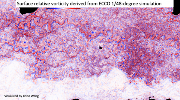
Project 3: Apply machine learning to predict ocean circulation
|
Disciplines: |
Earth Science, Data Science, Computer Science |
|
Mentor (JPL): |
Jinbo Wang (329B) Jinbo.Wang@jpl.nasa.gov 818 354 5936 |
|
Mentor (UCLA): |
Yizhou Sun (Computer Science), yzsun@cs.ucla.edu; https://web.cs.ucla.edu/~yzsun |
|
Background: |
The ocean, a turbulent and dynamic system, plays a critical role in the Earth's climate by transporting heat (Su et al., 2018), carbon, and nutrients, and influencing global weather patterns. Accurately predicting oceanic circulation is vital for understanding and mitigating the effects of climate change. However, the complex and dynamic nature of the oceanic system presents a significant challenge for traditional modeling approaches that requires extremely large amount of computing resources. Recent advancements in computational power and big data analysis have led to the emergence of machine learning as a promising tool for predicting oceanic circulation. This research seeks to explore the efficacy of machine learning algorithms (Huang et al., 2020, 2021) for predicting ocean circulation, providing a new approach to studying ocean physics and to synthesizing sporadic satellite measurements of the ocean surface. The results will have significant implications for advancing our understanding of the Earth's climate system and the role of the ocean in it. |
|
Description: |
The objective of this project is to train an existing machine learning algorithm using a high-resolution global ocean numerical simulation with an ultrahigh resolution of approximately 2 kilometers (Su et al., 2018). Our aim is to assess the effectiveness of this approach in predicting oceanic behavior and its potential for application in satellite oceanography and remote sensing. Through this investigation, we seek to further our understanding of the role of machine learning in oceanography and its potential to advance our knowledge of the Earth's climate system. The intern is expected to draft a manuscript by the end of the 10-week term.
|
|
References: |
Su, Z., Wang, J., Klein, P. et al. Ocean submesoscales as a key component of the global heat budget. Nat Commun 9, 775 (2018). https://doi.org/10.1038/s41467-018-02983-w Zijie Huang, Yizhou Sun, and Wei Wang, "Coupled Graph ODE for Learning Interacting System Dynamics," in Proc. of 2021 ACM SIGKDD Int. Conf. on Knowledge Discovery and Data Mining (KDD'21), Aug. 2021. [GitHub] Zijie Huang, Yizhou Sun, Wei Wang, "Learning Continuous System Dynamics from Irregularly-Sampled Partial Observations," in Thirty-fourth Conf. on Neural Information Processing Systems (NeurIPS'20), Dec. 2020. [Arxiv][GitHub] |
|
Student Requirements: |
Undergraduate and graduate students in Computer Science or Earth Sciences. Familiarity with physics and machine learning. Excellent communication and problem-solving skills |
|
Work Location: |
JPL |
Project 4: Early Detection of Drought Onset in CONUS Using Infrared Sounders
|
Project 5: Spacecraft Bus Technology Roadmaps
|
Disciplines: |
Aerospace engineering |
|
Mentor (JPL): |
Daniel Limonadi (800), Daniel.limonadi@jpl.nasa.gov |
|
Mentor (UCLA): |
Artur Davoyan, davoyan@seas.ucla.edu (https://samueli.ucla.edu/people/artur-davoyan/) |
|
Background: |
The JPL Earth Science and Technology Directorate is responsible for formulating mission concepts in response to Earth observation needs identified by NASA and the broader Earth science community via the decadal survey process. The last Earth science decadal survey was released in 2017 (https://nap.nationalacademies.org/catalog/24938/thriving-on-our-changing-planet-a-decadal-strategy-for-earth). The next one is scheduled for 2027. As part of getting ready for the next decadal, the science and engineering community would benefit from having a sense of where the key supporting technology for Earth observing spacecraft missions is headed in the next 10 years - i.e. what is existing state of the art capability, and what might reasonably be mature in the next 5-10 years. This information is important to help provide boundary conditions for what observing system concept capabilities can be reasonably planned for. Supporting technology is defined here as technology not directly related to instrument design. |
|
Description: |
Under the guidance of the mentor, research and generate roadmaps for expected technology capabilities in key spacecraft subsystems which drive science return and mission cost - telecommunications, onboard computing and non-volatile storage, attitude control, and propulsion capabilities, in addition to documenting launch cost trends. Identify items to watch/monitor as indicators of progress, and flag any potential investments in JPL strength areas (e.g. telecommunications). Submit a report and possibly a paper with the mentor as co-author capturing this information to share with the broader community. This work will entail looking up and reading journal papers and conference presentations, meeting with JPL subject matter experts in these domains, summarizing performance gains made in these key subsystems over the last 10-15 years, and looking into the viability of projecting capabilities into the future - either from those performance trends, or based on the discussions with subject matter experts, or both. |
|
References: |
https://www.nasa.gov/sites/default/files/atoms/files/2022_soa_full_0.pdf |
|
Student Requirements: |
Preferred - Aerospace engineering student who has completed a spacecraft design course or is otherwise familiar with key spacecraft subsystems and how they work together. Self-starter with the curiosity and persistence to do good research and reach out to JPL subject matter experts for interviews, document results in clear notes. Good synthesis skills to take research and interview results and summarize them in a way that is succinct, clear, and captures the key points. |
|
Work Location: |
On lab at JPL |
Project 6: Characterizing the 2020 and 2021 California mega fires and their impacts on air quality
|
Disciplines: |
Earth Sciences, air quality, remote sensing of atmospheric composition and landscape properties |
|
Mentor (JPL): |
Kazuyuki Miyazaki (Earth Science), kazuyuki.miyazaki@jpl.nasa.gov, 818-354-3266, https://science.jpl.nasa.gov/people/miyazaki/ Kevin Bowman (Earth Science), kevin.w.bowman@jpl.nasa.gov, 818-354-2995, |
|
Mentor (UCLA): |
Pablo Saide (Atmospheric and Oceanic Sciences), saide@atmos.ucla.edu, 310-825-1217, https://atmos.ucla.edu/people/faculty/pablo-saide |
|
Background: |
Six out of the seven largest wildfires in the California history occurred in 2020 and 2021. Together with other wildfires in the western US, they substinailly impacted local and remote air pollutions. Smoke from wildfire smokes has substantial impacts on human health, air quality, and radiative forcing of the atmosphere. Amplified wildfires are predicted under warming climate, while modifying its seasonal pattern (Buchholz et al., 2021). Satellite and ground-based observations routinely provide new insights into the distributions of wildfire plumes and their emissions. In particular, carbon monoxide (CO) can be used as a tracer for combustion and is useful for the study of biomass burning smoke. Combining recent high spatial resolution multiple satellite measurements with different vertical sensitivities, such as Cross-track Infrared Sounder (CrIS) developed at JPL and TROPOspheric Monitoring Instrument (TROPOMI), has the potential to identify CO distributions at different levels in the atmosphere. The overall quality of the CO satellite retrievals has been assessed previously (e.g., Martinez-Alonso et al., 2022). Nevertheless, their skill and sensitivity during extreme fire events remain unclear, especially for the most recent mega-fire events, which have been suggested to have different physical and chemical characteristics than previous fires. On the other hand, smoke event prediction using air quality models has been used to reduce smoke exposure. However, their performance, including temporal changes in plumes at various levels in the atmosphere, has been limited by the insufficient representation and understanding of fire smoke properties, such as injection height and emission distribution, and their performance during mega fires has not been well investigated yet. Models to evaluate range from operational air quality forecasts maintained by NOAA, such as HRRR-Smoke and RAP-Chem (Chow et al., 2022), to reanalysis systems that track trends on atmospheric compositions, such as JPL’s MOMO-Chem (Miyazaki et al., 2020). |
|
Description: |
We are seeking an undergraduate/graduate student intern to work on this topic for 10 weeks during the summer of 2023. The intern will gain experience in processing the latest satellite data produced from CrIS and TROPOMI for 2020 and 2021 and evaluating global and regional air quality models for California megafire events, focusing on recent findings regarding changes in the chemical and physical properties and seasonal pattern. The latest data from TROPOMI includes aerosol layer height in addition to CO concentration (Chen et al., 2021), which will be used to identify the three-dimensional structure of fire plume. This will lead to a development of new research capabilities at both JPL and UCLA and enhance collaboration between them. Deliverables will include an oral presentation and a final report. This research will help JPL develop a widely useable analysis, improve understanding of NASA's satellite data capabilities, and develop air quality models. |
|
References: |
Buchholz, R. R., Park, M., Worden, H. M., Tang, W., Edwards, D. P., Gaubert, B., … Magzamen, S. (2022). New seasonal pattern of pollution emerges from changing North American wildfires. Nature Communications, 13, 2043. doi:10.1038/s41467-022-29623-8 Chen, X., Wang, J., Xu, X., Zhou, M., Zhang, H., Castro Garcia, L., Colarco, P. R., Janz, S. J., Yorks, J., McGill, M., Reid, J. S., de Graaf, M., and Kondragunta, S.: First retrieval of absorbing aerosol height over dark target using TROPOMI oxygen B band: Algorithm development and application for surface particulate matter estimates, Remote Sensing of Environment, 265, 112674, https://doi.org/10.1016/j.rse.2021.112674, 2021. Miyazaki, K., Bowman, K. W., Yumimoto, K., Walker, T., and Sudo, K.: Evaluation of a multi-model, multi-constituent assimilation framework for tropospheric chemical reanalysis, Atmos. Chem. Phys., 20, 931–967, https://doi.org/10.5194/acp-20-931-2020, 2020. Chow, F. K., Yu, K. A., Young, A., James, E., Grell, G. A., Csiszar, I., et al. (2022). High-resolution smoke forecasting for the 2018 Camp Fire in California. Bulletin of the American Meteorological Society, 103(6), E1531-E1552. |
|
Student Requirements: |
Basic experience with Python or other programing language, willingness to learn about satellite data and wildfires |
|
Work Location: |
UCLA, JPL, or Remote |
Project 7: Dust Aerosol from SAGE-III/ISS observations
|
Mentor (JPL): |
Dr. Olga Kalashnikova, JPL, (US 329J- Aerosols and Clouds Group) |
|
Mentor (UCLA): |
Prof. Jasper Kok, AOS, UCLA (https://atmos.ucla.edu/people/faculty/jasper-kok) Dr. Ashok Kumar Gupta, AOS, UCLA ashokgupta@atmos.ucla.edu (https://orcid.org/0000-0002-2282-7266) |
|
Background: |
Desert dust aerosols by mass are the major contributor to global aerosol loading. Dust affects Earth's energy balance by scattering and absorbing shortwave and longwave radiation and by nucleating ice crystals. In modern times, dust aerosol loading has dramatically increased relative to preindustrial times (Kok et al., 2023). Dust lofted from Arabian Peninsula, East Asia, and Saharan regions through convection outflows could reach the middle to the upper troposphere and potentially affect the atmospheric radiative and thermodynamic properties and contribute to cloud formation. How the lofted aerosol influences the atmospheric radiative effects largely depends on the dust aerosol's vertical distribution, mass loading, and optical and microphysical properties. Therefore, before quantifying the atmospheric radiative effects of the dust aerosol, the first step is to accurately assess the vertical distribution of the dust, including its optical and microphysical properties. For this purpose, multi-wavelength observations from the Stratospheric Aerosol and Gas Experiment (SAGE; Thomason et. al., 2010) III instrument onboard the International Space Station (ISS) could be useful to determine the upper tropospheric dust aerosol and associated optical properties, but retrievals to do so have been largely missing in the literature. Moreover, this detection of dust aerosol in the upper troposphere will also be valuable while identifying the dominant role of dust in cirrus cloud formation (Froyd et al., 2022). |
|
Description: |
In this summer internship program, the student will conduct the following investigations- (1) Identify major dust outbreaks over the Africa, Middle East and Central Asia, and East Asia using NASA's A-train satellite observations during 2017-2021, when SAGE-III/ISS observations are available. (2) Over these dust-dominated regions, evaluate the SAGE-III/ISS observed aerosol extinction profiles at multiple wavelengths (384, 448, 520, 601, 676, 755, 869, 1022, and 1543 nm) to assess the dust's optical and microphysical properties. (3) For point (2), use the best fit (Levenberg-Marquardt method; Marquardt, 1963) approach between the precomputed look-up table (for a single mode log-normal distribution of dust aerosol; Huang et. al., 2023) and the observed aerosol extinction (SAGE-III/ISS) to generate the dust aerosol optical and microphysical properties. We expect that the results obtained from SAGE-III/ISS observations will improve our understanding of the vertical distribution of the dust aerosol in the middle-upper troposphere, especially over the dust-dominated regions in the Northern Hemisphere. |
|
References: |
|
|
Student Requirements: |
|
|
Work Location: |
UCLA |
Project 8: XAI Research for Unsupervised Segmentation
|
Disciplines: |
Machine Learning, Data Science, Wildfire Science |
|
Mentor (JPL): |
Dr. Nicholas LaHaye, nlahaye@jpl.nasa.gov |
|
Mentor (UCLA): |
Dr. Janine Baijnath-Rodino |
|
Background: |
NASA’s Earth observing instruments have provided comprehensive observations of aerosol plumes from wildfires. At present, JPL’s Segmentation, Instance Tracking, and data Fusion Using multi-SEnsor imagery (SIT-FUSE) utilizes an unsupervised machine learning (ML) framework that allows users to segment instances of objects like wildfires and smoke plumes in single and multi-sensor scenes from NASA’s satellite instruments with minimal human intervention, in low and no label environments (LaHaye et al., 2019,2021). |
|
Description: |
Here we propose to work with a JIFRESSE student to research adding Explainable AI (XAI) methods to the SIT-FUSE library to further our understanding of the relationship between input data, in this case, from airborne radiometers, as well as JPL’s UAVSAR, and the quality of the output segmentation. This would also, in turn aid upcoming missions like NISAR, mission development teams, as they look to build wildfire-detection-optimized instruments, and increase trust with the end customers of these datasets, physical scientists. |
|
References: |
Lahaye, N., Garay, M. J., Bue, B., El-Askary, H., Linstead, E. “A Quantitative Validation of Multi-Modal Image Fusion and Segmentation for Object Detection and Tracking”. Remote Sens. 2021, 13, 2364. https://doi.org/10.3390/rs13122364 Lahaye, N., Ott, J., Garay, M. J., El-Askary, H., and Linstead, E., “Multi-modal object tracking and image fusion with unsupervised deep learning,” IEEE Journal of Selected Topics in Applied Earth Observations and Remote Sensing, vol. 12, no. 8, pp. 3056-3066, Aug. 2019, doi: https://doi.org/10.1109/JSTARS.2019.2920234 |
|
Student Requirements: |
Experience with machine learning, python and machine learning libraries, like PyTorch |
|
Work Location: |
JPL |
Project 9: Understanding the Error Characteristics of Satellite-Derived Temperature and Water Fields Using High-Spatial Resolution Numerical Weather Forecasts
|
Disciplines: |
Atmospheric science, remote sensing, machine learning |
|
Mentor (JPL): |
Evan Fishbein (329E) Evan.Fishbein@jpl.nasa.gov, 818-825-6744, https://science.jpl.nasa.gov/people/fishbein |
|
Mentor (UCLA): |
Yu Gu (JIFRESSE & AOS), gu@atmos.ucla.edu, 310-634-6076, http://people.atmos.ucla.edu/gu/index.html Yun Lin (JIFRESSE), yunlin@g.ucla.edu |
|
Background: |
Numerical weather forecasting (NWF) relies on satellite-based observations to constrain the present conditions of the atmosphere. Historically weather forecast models and satellite observations had comparable 25-km spatial resolution, but the spatial resolution of NWF have increased to just a few kilometers. How do these resolution differences affect the use of the data and how can the high-resolution NWF data be used to improve the use of the satellite data. |
|
Description: |
The candidate will develop and use tools to sample satellite and NWF data to create a training data set. They will develop a neural network to predict errors in satellite-derived temperature and water vapor using NWF fields as predictors. |
|
References: |
Aumann, H. H., et al. (2003), AIRS/AMSU/HSB on the aqua mission: Design, science objectives, data products, and processing systems, IEEE Trans. Geoscience Rem. Sens., 41, 253-264. Blackwell, W.J. (2009), Neural Networks in Atmospheric Remote Sensing, Artech House, 234pp. |
|
Student Requirements: |
Experience using python numpy and/or IDL. Knowledge of atmospheric science, machine learning, radiative transfer, data assimilation and inverse theory desirable. |
|
Work Location: |
JPL and/or UCLA |
Project 10: Global Rapid Damage Mapping System with Spaceborne SAR Data
|
Disciplines: |
Earthquake engineering, synthetic aperture radar, damage proxy maps |
|
Mentor (JPL): |
Eric Fielding (329A), eric.j.fielding@jpl.nasa.gov, 818.354.9305, https://science.jpl.nasa.gov/people/fielding/ |
|
Mentor (UCLA): |
Jonathan P. Stewart (Civil Engineering), jstewart@seas.ucla.edu, 310 206 2990, https://uclageo.com/jstewart/ |
|
Background: |
Damage Proxy Maps (DPMs) based on spaceborne Synthetic Aperture Radar (SAR) data are rapidly generated by NASA/JPL following extreme events such as earthquakes. These maps indicate changes in surface conditions between two time periods, which is quantified by an index that is used to generate colorized DPMs. The questions being addressed in this research are the degree to which the change index indicates actual damage levels, as reflected by structural damage, ground rupture from faulting, ground disruption by liquefaction, and permanent ground deformations by landsliding. Information of field performance that is being considered is derived from reconnaissance by the Geotechnical Extreme Events Reconnaissance (GEER) Association. The Damage Proxy Map method is a promising application for the upcoming NASA-ISRO SAR (NISAR) mission. |
|
Description: |
The summer internship will involve training on how DPMs are generated and analysis of data from an extreme event (Yun, et al., 2015). The anticipated study area is central Italy, which was affected by a 2016 earthquake sequence that produced extensive surface faulting, structural damage, and landslides (GEER 2016, 2017; Huang et al., 2017). |
|
References: |
GEER (2016). "Engineering reconnaissance of the 24 August 2016 Central Italy Earthquake: Ver 2," GEER Report 050, Geotechnical Extreme Events Reconnaissance Association. DOI:10.5072/FK2NZ85W2R. GEER (2017). "Engineering reconnaissance following the October 2016 central Italy earthquakes: Ver 2," GEER Report 050D, Geotechnical Extreme Events Reconnaissance Association. DOI:10.18118/G6HS39. Yun, S.-H., K. Hudnut, S. Owen, F. Webb, M. Simons, P. Sacco, E. Gurrola, G. Manipon, C. Liang, E. Fielding, P. Milillo, H. Hua, and A. Coletta (2015). Rapid Damage Mapping for the 2015 Mw 7.8 Gorkha Earthquake Using Synthetic Aperture Radar Data from COSMO–SkyMed and ALOS-2 Satellites, Seismol. Res. Lett. 86, no. 6, 1549-1556, doi:10.1785/0220150152. Huang, M.-H., E. J. Fielding, C. Liang, P. Milillo, D. Bekaert, D. Dreger, and J. Salzer (2017). Coseismic deformation and triggered landslides of the 2016 Mw 6.2 Amatrice earthquake in Italy, Geophysical Research Letters 44, no. 3, 1266-1274, doi:10.1002/2016GL071687. |
|
Student Requirements: |
Junior or senior standing in Civil Engineering or earth sciences |
|
Work Location: |
Either JPL or UCLA campus |